LiDAR Drone Market Performance, Development, Opportunity And Forecast, 2028

According to Fortune Business Insights™, the global LiDAR drone market was valued at USD 129.0 million in 2020 and is projected to grow from USD 143.0 million in 2021 to USD 455.0 million by 2028, representing a CAGR of 17.98% during the forecast period. North America led the market in 2020 with a 39.74% share, driven by extensive adoption across infrastructure, forestry, and defense applications. However, the COVID-19 pandemic disrupted operations, causing a decline of -5.6% compared to the average annual growth between 2017 and 2019.
What Are LiDAR Drones?
LiDAR drones are unmanned aerial vehicles (UAVs) equipped with Light Detection and Ranging (LiDAR) sensors. These drones are transforming industries by enabling high-precision 3D mapping, terrain modeling, structural inspections, and object detection. Compared to traditional surveying methods, LiDAR drones offer:
Faster data collection
- Higher accuracy
- Lower operational costs
- Industries benefiting from these technologies include construction, precision
- agriculture, forestry, archaeology, and environmental monitoring.
Market Segmentation
By Product:
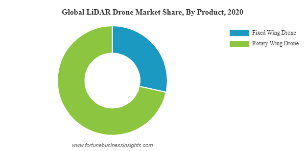
Rotary-Wing Drones hold the largest market share due to their cost-effectiveness, easy maneuverability, and suitability for 3D mapping and corridor applications. Fixed-Wing Drones are expected to register the fastest growth, driven by requirements for long-range detection, Beyond Line of Sight (BLOS) operations, and higher payload capacities.
By LiDAR Type:
Mechanical LiDAR dominated the market in 2020, widely used for 360-degree data detection across large areas. In contrast, Solid-State LiDAR is projected to grow the fastest, owing to its compact design, lower cost, and superior resolution for precision mapping and corridor applications.
By Range:
Short-Range LiDAR held the largest share in 2020, favored for low-altitude operations due to cost efficiency and ease of use. Long-Range LiDAR is expected to expand rapidly, leveraging advanced laser technology for high-altitude and long-distance detection.
By Application:
Mapping and Cartography accounted for the largest segment in 2020, driven by infrastructure development, agriculture, oil & gas, and energy utility projects. Other applications such as environmental monitoring, surveillance, exploration, detection, and precision agriculture are also contributing significantly to market growth.
Key Growth Drivers
1. Rising Adoption of Cost-Effective 3D Mapping
LiDAR drones provide accurate georeferenced data at a fraction of the cost of traditional methods. This has expanded their applications to vegetation monitoring, precision farming, archaeology, and large-scale infrastructure surveys.
2. Increased Deployment in Corridor Mapping
Surveying highways, railways, bridges, and shoreline infrastructure has become easier and more accurate with LiDAR drones. Their ability to generate high-resolution point clouds at lower operational costs makes them essential for modern infrastructure projects.
3. Technological Advancements
The integration of next-generation UAV LiDAR sensors, such as optical altimeter-based systems and MEMS (Micro-Electromechanical Systems) laser scanners, has improved mapping precision and resolution. These innovations enhance operational efficiency for government, industrial, and environmental projects.
Market Restraints
Despite rapid adoption, the market faces some challenges:
- Strict aviation regulations governing UAV operations
- High acquisition and maintenance costs compared to alternatives like
- photogrammetry
- Shortage of skilled operators capable of handling advanced UAV systems
Information Source:
https://www.fortunebusinessinsights.com/lidar-drone-market-102602
Regional Insights
North America: Valued at USD 51.27 million in 2020; continues to lead due to favorable regulations and strong R&D. Key players include Velodyne Lidar, Phoenix LiDAR Systems, and LiDARUSA.
Europe: Second-largest market, fueled by 3D mapping demand and environmental monitoring. Key manufacturers: Leica Geosystems, Delair, YellowScan.
Asia Pacific: Fastest-growing region due to domestic UAV manufacturers in China and India and expanding applications in agriculture.
Middle East & Africa: Moderate growth driven by government projects and infrastructure development.
Rest of the World: Gradual growth, supported by cost-effective drone surveys in countries such as Turkey and South Africa.
Leading Players
Key companies are focusing on R&D, innovation, strategic partnerships, and acquisitions to expand their market presence:
- Velodyne Lidar, Inc. (U.S.)
- Teledyne Optech Inc. (Canada)
- RIEGL Laser Measurement Systems GmbH (Austria)
- Delair SAS (France)
- Phoenix LiDAR Systems (U.S.)
- Leica Geosystems AG (Switzerland)
- Yellow Scan (France)
- LiDARUSA (U.S.)
- SZ DJI Technology Co., Ltd (China)
- Benewake (China)
- RoboSense (China)
- Sick AG (Germany)
- Microdrones (Germany)
Recent Developments
July 2021: Microdrones completed a high-precision LiDAR survey in Minas Gerais, Brazil, covering 10 km² of a mining complex with three dams, demonstrating efficiency in large-scale industrial applications.